INTRODUCTION
Over the past 30 years, images from NASA spacecraft have revealed our neighboring planets
and moons to be surprisingly diverse and complex worlds. These images are usually shown as
two-dimensional photographs. This collection of 3-D images of the planets and their moons
provides a unique perspective, and allows us to sense the topography and ruggedness of
these planetary surfaces in ways that are otherwise not possible. The slide set features
representative 3-D images of the Sun, planets, moons, and asteroids, and an overview of
the entire solar system. The slide set also features prominent examples of each major type
of geologic feature, including impact craters, tectonic features, volcanos, and river
valleys. Images from the surfaces of the Moon and Mars, and of atmospheric features, are
also included. The slides are organized by planet, starting from the Sun and continuing
out to Pluto. The slides can also be rearranged and presented by geologic topic; a sample
geologic tour is included at the end of this booklet. Terms appearing in the glossary are
underlined at their first occurrence in this booklet.
|
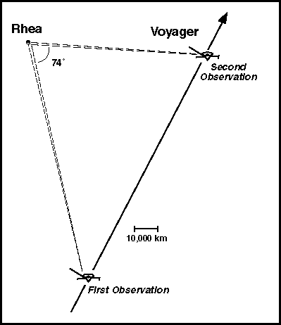
Most of these 3-D images were obtained from hundreds to tens of thousands of kilometers distance from the target surface. To achieve the 3-D effect from these distances, each slide was constructed from two separate images taken at two different times and positions (sometimes tens of thousands of kilometers apart). These two views simulate the stereo view we would have if our eyes were very far apart. The illustration below shows how Voyager obtained two separate views of Saturn's moon Rhea in November 1980. These two views were later digitally recombined to produce the 3-D view in slide #36. Because of this large separation, many of these views provide an exaggerated sense of relief (the relative degree of exaggeration, where available, is given with each caption). |
IMPORTANT NOTES ON 3-D SLIDE PROJECTION:
Preview the slides to be sure that the 3-D effect works in your lecture room and with your
projection system. A bright projector is recommended. Red-blue 3-D glasses are required
for viewing, with the red lens over the left eye. The audience should view the slides from
in front of the screen, as viewing from the sides reduces the stereo effect. Allow the
audience ~30 seconds to adjust their vision. (A small fraction of the population is unable
to see in stereo.) These slides must be shown in the proper orientation (top down and rear
side toward screen for most projectors), or the stereo effect will not occur or will be
reversed.
PLANETARY TOUR
1. A napkorona röntgenfényben Nap
 This view
of the Sun was obtained in 1994 by Yohkoh, a Japanese Earth-orbiting solar observatory.
The Sun is a 1,390,000-kilometer-wide sphere of hydrogen and helium that is powered by
nuclear fusion. The image shows the Sun at X-ray wavelengths and highlights prominences
and gaseous activity in the Sun's hot atmosphere, or corona. Prominences form large loops
of hot ionized gas that travel along magnetic field lines, which are highly distorted near
the Sun's surface. This stereo image uses the Sun's rotation to provide stereo relief. The
two views used to construct this image were obtained 13 hours apart.
This view
of the Sun was obtained in 1994 by Yohkoh, a Japanese Earth-orbiting solar observatory.
The Sun is a 1,390,000-kilometer-wide sphere of hydrogen and helium that is powered by
nuclear fusion. The image shows the Sun at X-ray wavelengths and highlights prominences
and gaseous activity in the Sun's hot atmosphere, or corona. Prominences form large loops
of hot ionized gas that travel along magnetic field lines, which are highly distorted near
the Sun's surface. This stereo image uses the Sun's rotation to provide stereo relief. The
two views used to construct this image were obtained 13 hours apart.
2. Discovery Rupes (Thrust Fault) Discovery
Tartomány, Merkúr
 Mariner 10
images of Mercury, the innermost planet, revealed a heavily cratered landscape similar to
the Moon, but also revealed prominent topographic scarps. One of these scarps,
Discovery Rupes, is shown here. This scarp is roughly 650 kilometers long and
2 kilometers high. Discovery Rupes crosses the floors of two old impact craters, the
largest of which is 70 kilometers across. Both of these craters have been shortened
in diameter, thereby indicating that Discovery Rupes is a thrust fault and that the crust
of Mercury has been compressed. These scarps indicate that Mercury shrank a little early
in its history. This shrinkage was probably due to global cooling of the interior, causing
the outer surface to shrink and crumple like the skin of a dried apple. (Mariner 10
images 27399, 166619.)
Mariner 10
images of Mercury, the innermost planet, revealed a heavily cratered landscape similar to
the Moon, but also revealed prominent topographic scarps. One of these scarps,
Discovery Rupes, is shown here. This scarp is roughly 650 kilometers long and
2 kilometers high. Discovery Rupes crosses the floors of two old impact craters, the
largest of which is 70 kilometers across. Both of these craters have been shortened
in diameter, thereby indicating that Discovery Rupes is a thrust fault and that the crust
of Mercury has been compressed. These scarps indicate that Mercury shrank a little early
in its history. This shrinkage was probably due to global cooling of the interior, causing
the outer surface to shrink and crumple like the skin of a dried apple. (Mariner 10
images 27399, 166619.)
Location: 56.5 S, 41.0 W Image Width: 380 kilometers
Vertical Exaggeration: 4.2× normal Image Resolution: 440
meters/pixel
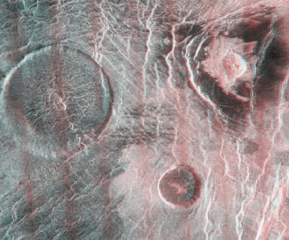
3. Kaikilani (komplex kráter) Nsomeka Planitia,
Vénusz
 Over 950
impact craters have been identified on Venus. The largest crater in this view, Kaikilani,
is 20 kilometers across and about 1 kilometer deep; the smaller unnamed crater
is 9 kilometers across. Kaikilani is a typical complex crater on Venus. The conical
central peak formed when the floor of the crater rebounded upward during the late stages
of crater formation. The scarps along the rim are terraces formed when portions of the rim
collapsed along concentric faults. Because these two craters have undergone nearly
identical stages of degradation, they may have formed simultaneously due to the impact of
a binary asteroid (comprised of two asteroids very close to or touching each other) or an
asteroid with a small satellite, such as Ida. (Magellan image F-MIDR 35S163.)
Over 950
impact craters have been identified on Venus. The largest crater in this view, Kaikilani,
is 20 kilometers across and about 1 kilometer deep; the smaller unnamed crater
is 9 kilometers across. Kaikilani is a typical complex crater on Venus. The conical
central peak formed when the floor of the crater rebounded upward during the late stages
of crater formation. The scarps along the rim are terraces formed when portions of the rim
collapsed along concentric faults. Because these two craters have undergone nearly
identical stages of degradation, they may have formed simultaneously due to the impact of
a binary asteroid (comprised of two asteroids very close to or touching each other) or an
asteroid with a small satellite, such as Ida. (Magellan image F-MIDR 35S163.)
Location: 33.0 S, 163.0 E Image Width: 60 kilometers
Vertical Exaggeration: ~6× normal Image Resolution: 75
meters/pixel
4. Carmenta Farra (Pancake Domes) Eistla Regio,
Vénusz
 Among the
most unusual volcanic features observed on Venus are these circular, flat-topped volcanic
domes, called pancake domes. This group of pancake domes is called Carmenta Farra. The
largest of these domes is 65 kilometers across and roughly 1 kilometer high. A
small crater near the center of each dome may have been the source vent for the lava. The
center of the largest dome appears to be depressed below the elevation of the margin of
the dome. This may be due to partial withdrawal of magma shortly after the eruption.
Among the
most unusual volcanic features observed on Venus are these circular, flat-topped volcanic
domes, called pancake domes. This group of pancake domes is called Carmenta Farra. The
largest of these domes is 65 kilometers across and roughly 1 kilometer high. A
small crater near the center of each dome may have been the source vent for the lava. The
center of the largest dome appears to be depressed below the elevation of the margin of
the dome. This may be due to partial withdrawal of magma shortly after the eruption.
The unusual morphology of these volcanos suggests that they may have a composition different from that of shield volcanos on Venus. On Earth, thick lava flows and domes are usually associated with lavas that are relatively sticky or viscous. These lavas also tend to be richer in silica than basalt, such as dacite or rhyolite. Whether this is true on Venus as well is not known. These domes could also be explained by the eruption of basalt at unusually slow rates.
The bright spot at upper right is the 12-kilometer-wide impact crater Margarita. It is
bowl-shaped, although a small mound is visible at bottom. The bright material surrounding
the crater is blocky ejecta, while the dark material may be due to effects of the impact
blast or to finer debris, which appears dark at radar wavelengths. (Magellan image
CI-MIDR 15N009.)
Location: 13.0 N, 8.0 E Image Width: 150 kilometers
Vertical Exaggeration: ~6× normal Image Resolution: 240
meters/pixel
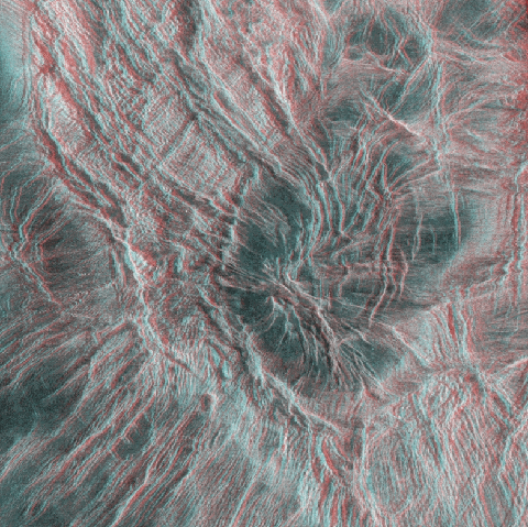
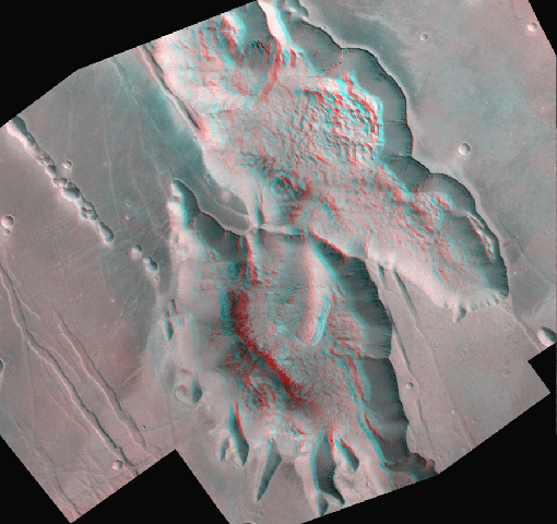
5. Calderas and Tessera Ovda Regio, Vénusz
 Volcanism
and tectonism are the dominant geologic processes on Venus. This Magellan 3-D view
shows two large volcanic calderas (lower right) on the southern margin of Ovda
Regio in the Aphrodite Terra highlands. The largest of these calderas measures 80 ×
45 kilometers and is roughly 1.5 kilometers deep. Like most calderas, these
probably formed when magma chambers were partially emptied during volcanic eruptions. The
roofs of the chambers then sagged downward to fill the void, forming one or more
concentric ring faults. Ring faults are clearly preserved in these calderas due to the
lack of extensive erosion on Venus.
Volcanism
and tectonism are the dominant geologic processes on Venus. This Magellan 3-D view
shows two large volcanic calderas (lower right) on the southern margin of Ovda
Regio in the Aphrodite Terra highlands. The largest of these calderas measures 80 ×
45 kilometers and is roughly 1.5 kilometers deep. Like most calderas, these
probably formed when magma chambers were partially emptied during volcanic eruptions. The
roofs of the chambers then sagged downward to fill the void, forming one or more
concentric ring faults. Ring faults are clearly preserved in these calderas due to the
lack of extensive erosion on Venus.
West of these calderas is a patch of tessera (upper left), a highly fractured terrain
type frequently observed on Venus. Tessera is one of the oldest terrain types observed on
Venus and formed as a result of complex tectonic forces. The parallel and cross-cutting
valleys and ridges formed during periods of extension and compression in the crust of
Venus. The dark smooth areas within and near the tessera are volcanic plains that have
partially flooded the older tessera. (Magellan image F-MIDR 105070.)
Location: 10.0 S, 70.0 E Image Width: 270 kilometers
Vertical Exaggeration: ~6× normal Image Resolution: 580
meters/pixel
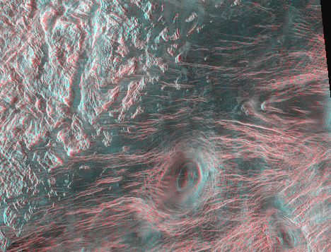
6. Korona Ovda Regio, Vénusz
 This
Magellan view of Ovda Regio shows a corona, a large volcanic and tectonic structure
common on Venus. Coronae are characterized by radial and concentric scarps and ridges and
by small volcanos and lava flows. The relatively smooth center of this corona measures
80 kilometers across and is about 3 kilometers lower in elevation than the
surrounding ridges. Several episodes of deformation are apparent in this corona. Many of
the concentric fractures and graben formed first, and then were faulted by the
prominent radial fault system. Several irregular volcanic pits are visible on the flanks
of this structure. Coronae may form when a region is uplifted and then collapses downward.
One possible interpretation is that these features are collapsed volcanic structures,
probably related to upwelling of material from deep in the mantle. (Magellan
image F-MIDR 00N076.)
This
Magellan view of Ovda Regio shows a corona, a large volcanic and tectonic structure
common on Venus. Coronae are characterized by radial and concentric scarps and ridges and
by small volcanos and lava flows. The relatively smooth center of this corona measures
80 kilometers across and is about 3 kilometers lower in elevation than the
surrounding ridges. Several episodes of deformation are apparent in this corona. Many of
the concentric fractures and graben formed first, and then were faulted by the
prominent radial fault system. Several irregular volcanic pits are visible on the flanks
of this structure. Coronae may form when a region is uplifted and then collapses downward.
One possible interpretation is that these features are collapsed volcanic structures,
probably related to upwelling of material from deep in the mantle. (Magellan
image F-MIDR 00N076.)
Location: 2.0 N, 74.0 E Image Width: 187 kilometers
Vertical Exaggeration: ~6× normal Image Resolution: 240
meters/pixel
7. Ridge Belt Ishtar Terra, Vénusz
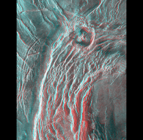 This
600-kilometer-long, 100-kilometer-wide belt of closely spaced parallel ridges forms a
gentle topographic rise located near Laima Tessera on Venus. The ridges are probably
formed by compressional thrust faults, folds, or a combination of both. The origin of this
compression is not well understood but is probably related to horizontal buckling of the
crust. Also, a set of narrow extensional graben (left) formed to the west of the ridge
belt. These graben probably formed during crustal extension, possibly in response to
stresses associated with formation of the ridge belt. The large circular structure is the
32-kilometer-wide impact crater Geopert-Meyer. This crater exhibits a central peak and
several interior terraces below the crater rim and is typical of craters in this size
range. Geopert-Meyer formed by the impact of an asteroid that was large enough to
penetrate the thick atmosphere of Venus. (Magellan image F-MIDR 60N026.)
This
600-kilometer-long, 100-kilometer-wide belt of closely spaced parallel ridges forms a
gentle topographic rise located near Laima Tessera on Venus. The ridges are probably
formed by compressional thrust faults, folds, or a combination of both. The origin of this
compression is not well understood but is probably related to horizontal buckling of the
crust. Also, a set of narrow extensional graben (left) formed to the west of the ridge
belt. These graben probably formed during crustal extension, possibly in response to
stresses associated with formation of the ridge belt. The large circular structure is the
32-kilometer-wide impact crater Geopert-Meyer. This crater exhibits a central peak and
several interior terraces below the crater rim and is typical of craters in this size
range. Geopert-Meyer formed by the impact of an asteroid that was large enough to
penetrate the thick atmosphere of Venus. (Magellan image F-MIDR 60N026.)
Location: 58.7 N, 26.5 E Image Width: 120 kilometers
Vertical Exaggeration: ~6× normal Image Resolution: 210
meters/pixel
8. St. Helens vulkán Washington, USA, Föld
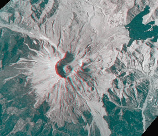 This
high-resolution 3-D view, obtained in September 1994 by space shuttle astronauts, shows
the summit crater and dacitic lava dome of Mount St. Helens. This once conical stratovolcano
erupted on May 18, 1980. The summit crater, which opens to the north, is about
9 kilometers across and 1.6 kilometers deep and formed when the north flank
collapsed in a massive avalanche. The crater has since been partially refilled by the
extrusion of viscous lava domes. The dome seen here formed in October 1986 and was
1 kilometer wide and 280 meters high.
This
high-resolution 3-D view, obtained in September 1994 by space shuttle astronauts, shows
the summit crater and dacitic lava dome of Mount St. Helens. This once conical stratovolcano
erupted on May 18, 1980. The summit crater, which opens to the north, is about
9 kilometers across and 1.6 kilometers deep and formed when the north flank
collapsed in a massive avalanche. The crater has since been partially refilled by the
extrusion of viscous lava domes. The dome seen here formed in October 1986 and was
1 kilometer wide and 280 meters high.
The irregular dark shape at the upper right is Spirit Lake. The avalanche that
triggered the eruption also slid into Spirit Lake, displacing it to the north. The
extensive gray areas to the north of the volcano were once heavily forested. These trees
were destroyed or buried in the lateral blast of the eruption. Despite the magnitude of
the 1980 eruption and the size of the area affected, it is dwarfed by some historical
eruptions, such as those of Long Valley caldera (slide #11), California, and Cerro Galan,
Argentina. (STS 64 images 64-51-25, 64-51-26.)
Location: 46.2 N, 122.2 W Image Width: 14 kilometers
Vertical Exaggeration: ~1× normal Image Resolution: 15
meters/pixel
9. A Kljucsevszkaja kitörése Kamcsatka,
Oroszország, Föld
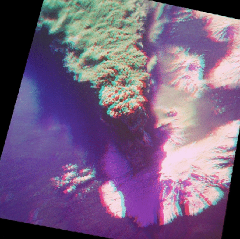 Space
shuttle astronauts witnessed this eruption of the large stratovolcano Klyuchevskaya on
October 1, 1994 (U.S. time). This near-vertical view shows the main eruption plume, which
consisted of hot gas and volcanic ash. The hot rising plume stalled at the tropopause, a
temperature inversion in the upper atmosphere. Strong eastward winds at an altitude of
8-10 kilometers drove the plume out to sea, forming a long narrow trail that
ultimately dispersed into the atmosphere. This is in contrast to eruption plumes on
Jupiter's moon Io, which, in the absence of an atmosphere, follow ballistic trajectories
and form circular umbrella-shaped eruption plumes hundreds of kilometers across.
Space
shuttle astronauts witnessed this eruption of the large stratovolcano Klyuchevskaya on
October 1, 1994 (U.S. time). This near-vertical view shows the main eruption plume, which
consisted of hot gas and volcanic ash. The hot rising plume stalled at the tropopause, a
temperature inversion in the upper atmosphere. Strong eastward winds at an altitude of
8-10 kilometers drove the plume out to sea, forming a long narrow trail that
ultimately dispersed into the atmosphere. This is in contrast to eruption plumes on
Jupiter's moon Io, which, in the absence of an atmosphere, follow ballistic trajectories
and form circular umbrella-shaped eruption plumes hundreds of kilometers across.
Klyuchevskaya is part of the Klichii group of eight stratovolcanos. This group lies in
the heart of the rugged Kamchatka Peninsula, one of the most volcanically active regions
on Earth. These volcanos are part of the "Ring of Fire," a belt of volcanos and
earthquakes that surrounds the Pacific Ocean (see slide #10). This geologic activity is
related to the subduction of oceanic crust into the mantle and is part of the
global tectonic system called plate tectonics. (STS 68 images 68-214-34, 68-214-35.)
Location: 55.9 N, 160.8 E Image Width: 53 kilometers
Vertical Exaggeration: 1× normal Image Resolution: 80
meters/pixel
10. Kurile-Kamcsatka Trench Northwestern Pacific
Basin, Föld
 This
unusual 3-D view of the northwestern Pacific Ocean Basin and northeastern Asia was created
using ocean bathymetry (i.e., depth) data and surface topography data from the National
Geophysical Data Center. These data were reprocessed to produce two shaded-relief
topographic models of the ocean floor from two different perspectives. These images have
been combined to give us a 3-D view of part of the seafloor, which covers 70% of the
Earth's surface but cannot be seen directly.
This
unusual 3-D view of the northwestern Pacific Ocean Basin and northeastern Asia was created
using ocean bathymetry (i.e., depth) data and surface topography data from the National
Geophysical Data Center. These data were reprocessed to produce two shaded-relief
topographic models of the ocean floor from two different perspectives. These images have
been combined to give us a 3-D view of part of the seafloor, which covers 70% of the
Earth's surface but cannot be seen directly.
The geology of the western Pacific region is dominated by plate tectonics. Earth's outer crust is divided into a series of large plates. The Pacific plate (forming the ocean floor) is being subducted or thrust beneath the Eurasian plate (to the upper left), forming a series of connected arcuate deep sea trenches and associated volcanic island arcs that nearly circle the Pacific Ocean. These subduction zones are sources of volcanism and earthquakes and together form the "Ring of Fire." The subduction process is unique to Earth (with the possible exception of several arcuate structures on Venus). At the same time, new crustal material is continually being formed at mid-ocean ridges.
Island arcs parallel ocean trenches and form when heat in the Earth's mantle partially
melts the descending plate. This molten material rises as magma, forming arcuate chains of
volcanos, such as the Kurile Island and Aleutian Island arcs (upper center and upper
right, respectively). Mount St. Helens (slide #8) and Klyuchevskaya (slide #9) are
examples of these volcanos. The large arcuate mountain range at center left is Japan,
which is a volcanic arc formed over a fragment of continental crust. The seafloor is also
dotted by numerous volcanic seamounts. The Emperor Seamount chain extends along center
right.
Image Width: ~6500 kilometers
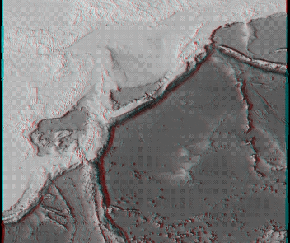
11. Owens-völgy California és Nevada, USA, Föld
 Owens
Valley, shown in this space shuttle view, is a large extensional fault-bounded trough on
the eastern side of the Sierra Nevada Mountains. This 3000-meter-deep valley is the
westernmost part of the Basin and Range structural province, which covers large parts of
Nevada and Utah. The Basin and Range formed when the crust in the western United States
was stretched in an east-west direction, producing a series of north-south-trending
extensional faults. This faulting produced a classic horst and graben topography
consisting of a series of alternating valleys and mountain ranges.
Owens
Valley, shown in this space shuttle view, is a large extensional fault-bounded trough on
the eastern side of the Sierra Nevada Mountains. This 3000-meter-deep valley is the
westernmost part of the Basin and Range structural province, which covers large parts of
Nevada and Utah. The Basin and Range formed when the crust in the western United States
was stretched in an east-west direction, producing a series of north-south-trending
extensional faults. This faulting produced a classic horst and graben topography
consisting of a series of alternating valleys and mountain ranges.
The snow-capped Sierra Nevada Mountains at bottom consist of numerous overlapping
granitic batholiths. They represent the deeply eroded core of a continental
volcanic arc that was active in the late Mesozoic era, and probably resembled the
Indonesian or Andean continental volcanic arcs of today. Most of the surface volcanic
materials have since been eroded away. Glaciation in recent times has produced a variety
of glacial valleys and landforms throughout the Sierras. A major eruption about
730,000 years ago formed the Long Valley caldera, the 17 × 32-kilometer-wide
circular depression at center left centered near the dark hook-shaped lake. Volcanic
activity in this area began around 3.2 million years ago, with the most recent
eruption occurring in the past 500 years. (STS 41G Large Format Camera images
41G-2059, 41G-2060.)
Location: 37.4 N, 118.3 W Image Width: 160 kilometers
Vertical Exaggeration: 3.1× normal Image Resolution: 140
meters/pixel
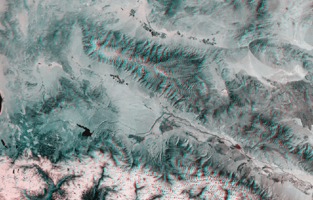
12.Grand Canyon Arizona, USA, Föld
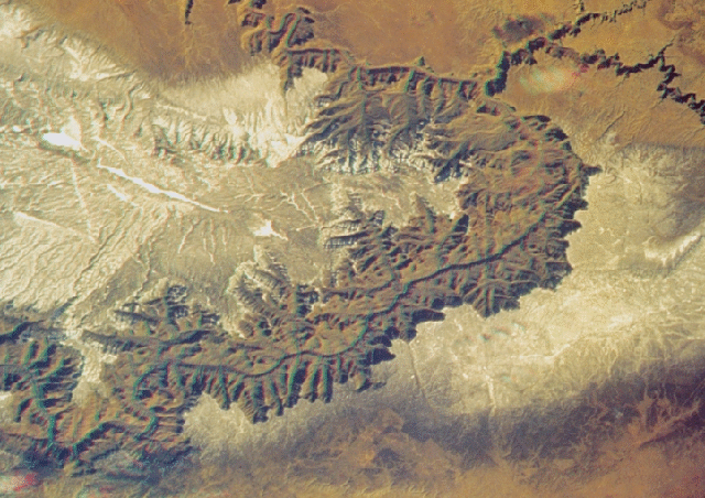 For over 5
million years the Colorado River has been carving the Grand Canyon through the Kaibab
Plateau, a broad upwarping (outlined by snow) within the larger Colorado Plateau. At its
widest, the canyon spans 29 kilometers and is 1.8 kilometers deep, although even
this is dwarfed by the Valles Marineris canyon system on Mars (slide #24). The walls of
the Grand Canyon are commonly likened to the pages of Earth's history, and comprise one of
the best exposed continuous vertical sections through the Earth's crust. The youngest
rocks are the 250-million-year-old Kaibab limestone formation along the canyon rim. The
oldest rocks, at bottom, are the Precambrian Vishnu schists, highly deformed metamorphic
rocks up to 2 billion years old. The step-like morphology of the canyon walls is
due to differential erosion of sedimentary and volcanic rock layers of varying resistance.
The deep narrow inner gorge is carved through the very resistant Precambrian metamorphic
rock. The narrow finger-like canyons along the rim may have formed by groundwater
sapping, a process that may be occurring on Mars (see slides #24 and #26). (STS 60
images 60-83-4, 60-83-6.)
For over 5
million years the Colorado River has been carving the Grand Canyon through the Kaibab
Plateau, a broad upwarping (outlined by snow) within the larger Colorado Plateau. At its
widest, the canyon spans 29 kilometers and is 1.8 kilometers deep, although even
this is dwarfed by the Valles Marineris canyon system on Mars (slide #24). The walls of
the Grand Canyon are commonly likened to the pages of Earth's history, and comprise one of
the best exposed continuous vertical sections through the Earth's crust. The youngest
rocks are the 250-million-year-old Kaibab limestone formation along the canyon rim. The
oldest rocks, at bottom, are the Precambrian Vishnu schists, highly deformed metamorphic
rocks up to 2 billion years old. The step-like morphology of the canyon walls is
due to differential erosion of sedimentary and volcanic rock layers of varying resistance.
The deep narrow inner gorge is carved through the very resistant Precambrian metamorphic
rock. The narrow finger-like canyons along the rim may have formed by groundwater
sapping, a process that may be occurring on Mars (see slides #24 and #26). (STS 60
images 60-83-4, 60-83-6.)
Location: 36.2 N, 112.1 W Image Width: 85 kilometers
Vertical Exaggeration: 1.7× normal Image Resolution: 115
meters/pixel
13. Vihar Brazília, Föld
 Space
shuttle astronauts captured this 3-D overhead view of thunderstorms in south-central
Brazil (about 200 kilometers west of Sao Paolo) in February 1984. Thunderstorms are
an important mechanism for redistributing solar heat absorbed by the Earth's surface.
Heating of the surface warms the lower atmosphere, and this warm moist air can be unstable
and can rise to form clouds. In the right circumstances, such updrafts can reach
50 kilometers per hour. As this air rises, it cools and rain condenses out of the
clouds. Thunderstorm updrafts reach heights of 13,500 meters (on average), where they
encounter a thermal inversion (the tropopause) at the base of the stratosphere and are no
longer buoyant. The cloud then spreads out laterally and forms the familiar anvil cloud.
Sometimes the center of this updraft can overshoot the tropopause and form a small domical
cloud at the top of the storm. (STS 41B images 41B-41-2342, 41B-41-2343.)
Space
shuttle astronauts captured this 3-D overhead view of thunderstorms in south-central
Brazil (about 200 kilometers west of Sao Paolo) in February 1984. Thunderstorms are
an important mechanism for redistributing solar heat absorbed by the Earth's surface.
Heating of the surface warms the lower atmosphere, and this warm moist air can be unstable
and can rise to form clouds. In the right circumstances, such updrafts can reach
50 kilometers per hour. As this air rises, it cools and rain condenses out of the
clouds. Thunderstorm updrafts reach heights of 13,500 meters (on average), where they
encounter a thermal inversion (the tropopause) at the base of the stratosphere and are no
longer buoyant. The cloud then spreads out laterally and forms the familiar anvil cloud.
Sometimes the center of this updraft can overshoot the tropopause and form a small domical
cloud at the top of the storm. (STS 41B images 41B-41-2342, 41B-41-2343.)
14. Eye, Typhoon Emilia Western Pacific, Föld
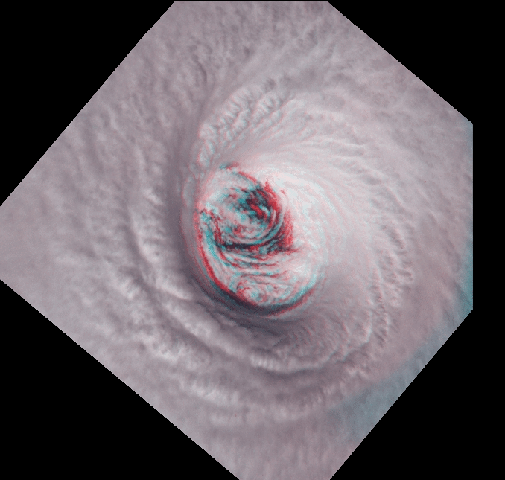 Space
shuttle astronauts captured this close-up view of the well-developed eye of Typhoon Emilia
in July 1994. Emilia was observed about 200 kilometers southeast of Hawai'i, and
briefly threatened the islands before veering away. The eye is a fundamental part of a
mature, well-organized hurricane. When the general circulation of a mature hurricane is
set up, the most intense storms and most powerful winds form a cylindrical wall of clouds
called the eye wall, which can be several tens of kilometers wide. Powerful updrafts in
the eye wall pull air into the storm along the ocean surface. Rising air in the eye wall
encounters the tropopause and spreads laterally. Some air flows downward into the center,
heating and dissipating the clouds and forming the clear calm eye. Most of this rising air
flows outward, however, forming a circular cloud deck over the hurricane called the
cirroform anvil, seen here surrounding the eye. (STS 65 images 65-92-14, 65-92-16.)
Space
shuttle astronauts captured this close-up view of the well-developed eye of Typhoon Emilia
in July 1994. Emilia was observed about 200 kilometers southeast of Hawai'i, and
briefly threatened the islands before veering away. The eye is a fundamental part of a
mature, well-organized hurricane. When the general circulation of a mature hurricane is
set up, the most intense storms and most powerful winds form a cylindrical wall of clouds
called the eye wall, which can be several tens of kilometers wide. Powerful updrafts in
the eye wall pull air into the storm along the ocean surface. Rising air in the eye wall
encounters the tropopause and spreads laterally. Some air flows downward into the center,
heating and dissipating the clouds and forming the clear calm eye. Most of this rising air
flows outward, however, forming a circular cloud deck over the hurricane called the
cirroform anvil, seen here surrounding the eye. (STS 65 images 65-92-14, 65-92-16.)
15. Haemus-hegység Mare Serenitatis, Hold
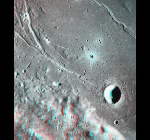 The
geologic diversity of the Moon is illustrated in this 3-D Apollo view of the southeastern
edge of the Serenitatis Basin. Most noticeable is the boundary between the rugged
highlands (Montes Haemus) and the smooth volcanic plains of Mare Serenitatis. The Montes
Haemus (or Haemus Mountains) are part of the prominent 740-kilometer-wide main ring of the
Serenitatis Basin, which formed 3.89 billion years ago when an asteroid
50-100 kilometers across slammed into the Moon. These mountains are
2-3 kilometers high, but were probably 5 kilometers high before the basin was
flooded a few hundred million years later by basaltic lava flows that formed the smooth
plains. Several volcanic pits, 3-5 kilometers across, can be seen along the edge of
the mountains. These may have been source vents for some of the lava flows.
The
geologic diversity of the Moon is illustrated in this 3-D Apollo view of the southeastern
edge of the Serenitatis Basin. Most noticeable is the boundary between the rugged
highlands (Montes Haemus) and the smooth volcanic plains of Mare Serenitatis. The Montes
Haemus (or Haemus Mountains) are part of the prominent 740-kilometer-wide main ring of the
Serenitatis Basin, which formed 3.89 billion years ago when an asteroid
50-100 kilometers across slammed into the Moon. These mountains are
2-3 kilometers high, but were probably 5 kilometers high before the basin was
flooded a few hundred million years later by basaltic lava flows that formed the smooth
plains. Several volcanic pits, 3-5 kilometers across, can be seen along the edge of
the mountains. These may have been source vents for some of the lava flows.
The fractures and graben at upper left are part of a concentric pattern along the outer
edge of Serenitatis. They formed when the great weight of the lava deposits caused the
basin to sag downward, stretching the crust along the edge. Concentric wrinkle ridges (at
upper right) formed in response to compressional stresses closer to the center of the
basin. Since then, numerous impact craters have formed in this area. The largest of these,
Sulpicius Gallus, is a simple bowl-shaped crater 12 kilometers across and
~2 kilometers deep. (Apollo 17 images AS17-M-1816, AS17-M-1818.)
Location: 20.0 N, 11.0 E Image Width: 86 kilometers
Vertical Exaggeration: 3.9× normal Image Resolution: 150
meters/pixel
16. King (komplex kráter) Farside Terra, Hold
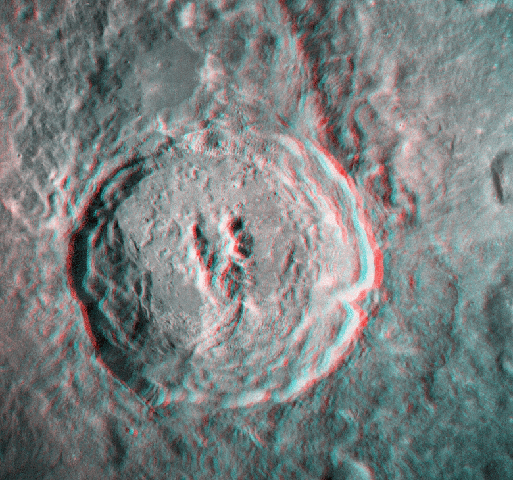 The large
impact crater King, shown in an Apollo view, formed as a result of the impact of an
asteroid (or comet) onto the lunar surface. King is 76 kilometers across and
5-5.5 kilometers deep. King is a classic complex crater and features a central peak
complex, rim terraces, and impact ejecta. Central peaks may be conical in shape or may be
a cluster of peaks, as shown here. These peaks are 1.5-2.5 kilometers high. Slumping
along the interior of the crater rim has formed a series of step-like terraces
3-4 kilometers wide. Terraces form during the late stages of crater formation when
shock-weakened rocks cannot support the crater rim, causing the crater rim to slump
downward along concentric faults. In larger craters, the tremendous heat and pressures of
impact melt large quantities of rock. This melted rock pooled in the bottom of King,
forming the craggy floor of the crater. Impact melt and ejecta were also
blasted out of the crater. Several large pools of solidified impact melt can also be seen
beyond the crater rim. The largest of these deposits (the flat depression directly above
the crater in this view) is 20 kilometers across. (Apollo 16 images AS16-M-1870,
AS16-M-1871.)
The large
impact crater King, shown in an Apollo view, formed as a result of the impact of an
asteroid (or comet) onto the lunar surface. King is 76 kilometers across and
5-5.5 kilometers deep. King is a classic complex crater and features a central peak
complex, rim terraces, and impact ejecta. Central peaks may be conical in shape or may be
a cluster of peaks, as shown here. These peaks are 1.5-2.5 kilometers high. Slumping
along the interior of the crater rim has formed a series of step-like terraces
3-4 kilometers wide. Terraces form during the late stages of crater formation when
shock-weakened rocks cannot support the crater rim, causing the crater rim to slump
downward along concentric faults. In larger craters, the tremendous heat and pressures of
impact melt large quantities of rock. This melted rock pooled in the bottom of King,
forming the craggy floor of the crater. Impact melt and ejecta were also
blasted out of the crater. Several large pools of solidified impact melt can also be seen
beyond the crater rim. The largest of these deposits (the flat depression directly above
the crater in this view) is 20 kilometers across. (Apollo 16 images AS16-M-1870,
AS16-M-1871.)
Location: 5.0 N, 120.6 E Image Width: 120 kilometers
Vertical Exaggeration: 1.7× normal Image Resolution: 150
meters/pixel
17. Catena Davy (Imbrium Basin Ejecta) Mare Nubium, Hold
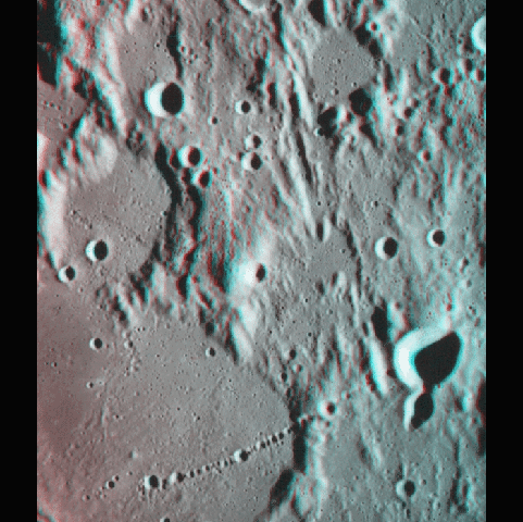 The linear
features in this area of the Moon are part of the ejecta deposit of the Imbrium impact
basin, which is located roughly 1500 kilometers to the north and formed
3.85 billion years ago. This texture is called Imbrium Sculpture and was first
interpreted as an impact-related feature by G. K. Gilbert in his telescopic
observations of the Moon in the 1890s. These radial grooves are caused by the collision of
massive quantities of broken rock ejected from large impact basins with the surrounding
surface. Ejecta of this type surround Imbrium and devastated or disturbed almost half the
lunar surface. Despite this, the degraded rims of several large and older impact craters
are visible. These craters have smooth dark floors and were partially filled by mare lava
plains associated with the nearby Mare Nubium.
The linear
features in this area of the Moon are part of the ejecta deposit of the Imbrium impact
basin, which is located roughly 1500 kilometers to the north and formed
3.85 billion years ago. This texture is called Imbrium Sculpture and was first
interpreted as an impact-related feature by G. K. Gilbert in his telescopic
observations of the Moon in the 1890s. These radial grooves are caused by the collision of
massive quantities of broken rock ejected from large impact basins with the surrounding
surface. Ejecta of this type surround Imbrium and devastated or disturbed almost half the
lunar surface. Despite this, the degraded rims of several large and older impact craters
are visible. These craters have smooth dark floors and were partially filled by mare lava
plains associated with the nearby Mare Nubium.
The unusual chain of craters at bottom, called Catena Davy, may be a chain of volcanic
craters or a chain of secondary craters formed by the large Orientale impact basin located
2000 kilometers to the west. Alternatively, it may have been formed by the impact of
a comet similar to Comet Shoemaker-Levy 9, which split into numerous fragments in 1992 and
struck Jupiter in 1994. In this case, it was an encounter with Earth that disrupted the
hypothetical comet. The largest craters in Catena Davy are 3 kilometers across. (Apollo
16 images AS16-M-1676, AS16-M-1678.)
Location: 10.2 S, 354.3 E Image Width: 84 kilometers
Vertical Exaggeration: 3.2× normal Image Resolution: 140
meters/pixel
18. Az Apollo 17 leszállási helye Taurus-Littrow
völgy, Hold
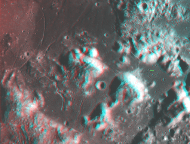 The Apollo
17 mission landed on the Moon on December 11, 1972. Of all the Apollo astronauts, Apollo
17 astronauts Gene Cernan and Harrison Schmidt spent the longest time out on the lunar
surface (more than 22 hours), traversed the greatest distance from the Lunar Module
(over 30 kilometers), and collected the largest number of lunar rocks (more than
120 kilograms).
The Apollo
17 mission landed on the Moon on December 11, 1972. Of all the Apollo astronauts, Apollo
17 astronauts Gene Cernan and Harrison Schmidt spent the longest time out on the lunar
surface (more than 22 hours), traversed the greatest distance from the Lunar Module
(over 30 kilometers), and collected the largest number of lunar rocks (more than
120 kilograms).
The Apollo 17 landing site (green cross) lies within the 2-kilometer-deep
Taurus-Littrow Valley on the eastern edge of Mare Serenitatis. The two high massifs
nearest the landing site, North and South Massif, were formed by the impact that created
the Serenitatis Basin 3.89 billion years ago. The astronauts visited the base of both
mountains. The Taurus-Littrow valley was partially filled by basaltic lavas a few hundred
million years after the impact. The bright material on the north side of South Massif is a
landslide deposit formed when ejecta from the 80-kilometer-wide bright-rayed crater Tycho
struck the top of South Massif. Tycho lies 2200 kilometers to the southwest of the
Apollo 17 landing site and is one of the youngest large craters on the Moon. Determining
the age of this landslide has enabled scientists to estimate that Tycho formed about
110 million years ago. (Apollo 17 images AS17-M-793, AS17-M-795.)
Location: 20.3 N, 30.7 W Image Width: 85 kilometers
Vertical Exaggeration: 3.7× normal Image Resolution: 135
meters/pixel
19. A Hold felszíne — Boulders Taurus-Littrow
völgy, Hold
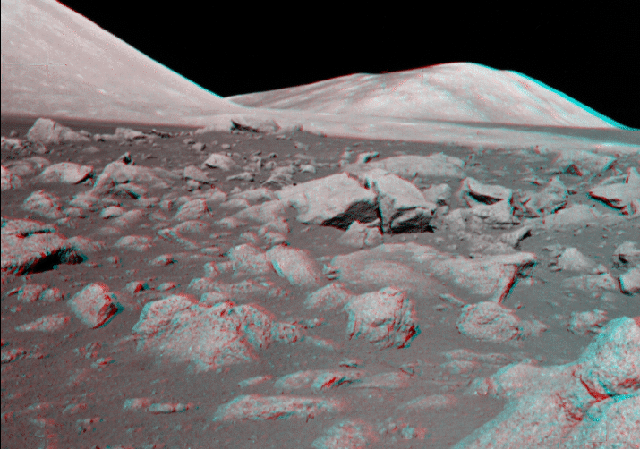 This
boulder field was visited by the Apollo 17 astronauts at station 5 on their second
moonwalk. These angular rocks are up to a meter across and were ejected onto the surface
during the formation of the crater Camelot, located just a few meters to the right of this
view. Camelot is 650 meters wide and is located 1 kilometer west of the Apollo
17 landing site. The view is toward the west. Apollo 17 landed in the Taurus-Littrow
valley in December 1972 (slide #18). The mountains in the distance are part of the rim of
the Serenitatis impact basin, a 900-kilometer-wide structure formed about
3.89 billion years ago. (Apollo 17 images AS17-145-22171 and AS17-145-22172.)
This
boulder field was visited by the Apollo 17 astronauts at station 5 on their second
moonwalk. These angular rocks are up to a meter across and were ejected onto the surface
during the formation of the crater Camelot, located just a few meters to the right of this
view. Camelot is 650 meters wide and is located 1 kilometer west of the Apollo
17 landing site. The view is toward the west. Apollo 17 landed in the Taurus-Littrow
valley in December 1972 (slide #18). The mountains in the distance are part of the rim of
the Serenitatis impact basin, a 900-kilometer-wide structure formed about
3.89 billion years ago. (Apollo 17 images AS17-145-22171 and AS17-145-22172.)
20. SA Hold felszíne — urhajós Oceanus
Procellarum, Hold
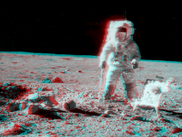 Charles
Conrad captured this 3-D view of astronaut Alan Bean performing scientific tasks on the
Moon during the Apollo 12 mission. Bean is holding a drill core tube used for
extracting deep soil samples. The large square object at right is a tool carrier. The
bulky pressure suit he is wearing weighs 190 pounds on Earth but only 30 pounds
on the Moon. Apollo 12 landed in November 1969 in eastern Oceanus Procellarum, a
basaltic lava plain that formed about 3.1 billion years ago. A small crater and
several small boulders are visible at left. (Apollo 12 images AS12-49-7318 and
AS12-49-7319.)
Charles
Conrad captured this 3-D view of astronaut Alan Bean performing scientific tasks on the
Moon during the Apollo 12 mission. Bean is holding a drill core tube used for
extracting deep soil samples. The large square object at right is a tool carrier. The
bulky pressure suit he is wearing weighs 190 pounds on Earth but only 30 pounds
on the Moon. Apollo 12 landed in November 1969 in eastern Oceanus Procellarum, a
basaltic lava plain that formed about 3.1 billion years ago. A small crater and
several small boulders are visible at left. (Apollo 12 images AS12-49-7318 and
AS12-49-7319.)
21. A Hold felszíne — a holdautó Hadley Rille,
Hold
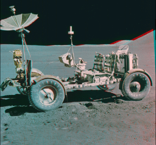 The Lunar
Roving Vehicle (LRV), shown in this 3-D Apollo 15 view, was a battery-powered buggy
driven by astronauts during the Apollo 15, 16, and 17 missions. The rover permitted
astronauts to venture greater distances from the Lunar Module because of its speed and
ability to navigate the lunar surface. The maximum speed of the LRV was about
13 kilometers per hour, but for safety reasons, the cruise speed was limited to
6-7 kilometers per hour. The total traverse distance of the Apollo 15 LRV was
28 kilometers. The rover was equipped with a high-gain antenna (the metallic umbrella
seen on the left) for communications between the astronauts and Mission Control in
Houston, a television camera (the box in front of the high-gain antenna), and a low-gain
antenna (the aerial antenna located between the seats). The wheels were constructed of
flexible woven piano wire. Titanium treads helped provide traction on the lunar surface.
Apollo 15 landed at the foot of the Apennine Mountains in July 1971. (Apollo 15
images AS15-88-11901 and AS15-88-11902.)
The Lunar
Roving Vehicle (LRV), shown in this 3-D Apollo 15 view, was a battery-powered buggy
driven by astronauts during the Apollo 15, 16, and 17 missions. The rover permitted
astronauts to venture greater distances from the Lunar Module because of its speed and
ability to navigate the lunar surface. The maximum speed of the LRV was about
13 kilometers per hour, but for safety reasons, the cruise speed was limited to
6-7 kilometers per hour. The total traverse distance of the Apollo 15 LRV was
28 kilometers. The rover was equipped with a high-gain antenna (the metallic umbrella
seen on the left) for communications between the astronauts and Mission Control in
Houston, a television camera (the box in front of the high-gain antenna), and a low-gain
antenna (the aerial antenna located between the seats). The wheels were constructed of
flexible woven piano wire. Titanium treads helped provide traction on the lunar surface.
Apollo 15 landed at the foot of the Apennine Mountains in July 1971. (Apollo 15
images AS15-88-11901 and AS15-88-11902.)
22. A Hold felszíne — a talaj közelképe Fra
Mauro Highlands, Hold
 This
high-resolution 3-D view of the lunar soil is one of several obtained using a close-up
stereoscopic camera placed at different locations by the Apollo 14 astronauts during their
moonwalks. A "raindrop" pattern can be seen in this close-up image of
undisturbed lunar soil. The raindrop patterns noticed by the astronauts are small pits
formed by the continual impact of micrometeorites (smaller than 1 millimeter) into
the lunar soil. Rock samples brought back from the Moon have impact pits as small as a few
millimeters across. Apollo 14 landed in the Fra Mauro highlands in February 1971. (Apollo
14 image AS14-77-10370.)
This
high-resolution 3-D view of the lunar soil is one of several obtained using a close-up
stereoscopic camera placed at different locations by the Apollo 14 astronauts during their
moonwalks. A "raindrop" pattern can be seen in this close-up image of
undisturbed lunar soil. The raindrop patterns noticed by the astronauts are small pits
formed by the continual impact of micrometeorites (smaller than 1 millimeter) into
the lunar soil. Rock samples brought back from the Moon have impact pits as small as a few
millimeters across. Apollo 14 landed in the Fra Mauro highlands in February 1971. (Apollo
14 image AS14-77-10370.)
Vertical Exaggeration: 2× normal Image Width: 82
millimeters
23. Apollinaris Patera Elysium Planitia, Mars
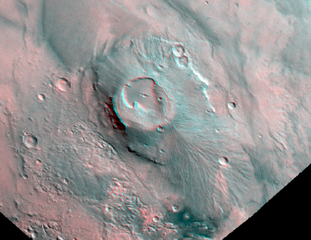 Apollinaris
Patera, Mars, is a complex shield volcano 180 × 280 kilometers across and
5 kilometers high. Shield volcanos are large volcanic cones with gently sloping
flanks. Apollinaris features an unusually large complex summit caldera 85 kilometers
across and 1 kilometer deep, and a basal scarp up to 1 kilometer high similar to
that observed at Olympus Mons. The steep flank to the southeast (to left) is also unusual.
A broad fan-shaped volcanic deposit formed on the southern flank of the volcano (to lower
right) when lavas breached the southern rim of the caldera. The caldera itself formed when
the roof of the underground magma chamber partially collapsed. The morphology of
Apollinaris Patera is unusual, perhaps due to different lava composition or to the role of
water/ice during eruption. Apollinaris Patera is located on the southern edge of the
Elysium Planitia volcanic province and is perhaps more than 3.5 billion years old. (Viking
1 images 603A42, 639A92.)
Apollinaris
Patera, Mars, is a complex shield volcano 180 × 280 kilometers across and
5 kilometers high. Shield volcanos are large volcanic cones with gently sloping
flanks. Apollinaris features an unusually large complex summit caldera 85 kilometers
across and 1 kilometer deep, and a basal scarp up to 1 kilometer high similar to
that observed at Olympus Mons. The steep flank to the southeast (to left) is also unusual.
A broad fan-shaped volcanic deposit formed on the southern flank of the volcano (to lower
right) when lavas breached the southern rim of the caldera. The caldera itself formed when
the roof of the underground magma chamber partially collapsed. The morphology of
Apollinaris Patera is unusual, perhaps due to different lava composition or to the role of
water/ice during eruption. Apollinaris Patera is located on the southern edge of the
Elysium Planitia volcanic province and is perhaps more than 3.5 billion years old. (Viking
1 images 603A42, 639A92.)
Location: 8.5 S, 186.0 W Image Width: 410 kilometers
Vertical Exaggeration: 4× normal Image Resolution: 600
meters/pixel
24. Eastern Tithonium Chasma Valles Marineris, Mars
 Eastern
Tithonium Chasma forms just one branch of the vast Valles Marineris canyon complex created
within the last 3 billion years. Valles Marineris is over 4000 kilometers long,
wider than the United States. Tithonium Chasma is 50 kilometers wide and over
6 kilometers deep in this area. In comparison, the Grand Canyon (slide #12) is about
175 kilometers long, 30 kilometers wide, and only 2 kilometers deep. Many
martian canyon-forming processes are illustrated in this view. The canyons were initiated
by extensional fracturing and pulling apart of the crust during the uplift of the vast
Tharsis plateau. Landslides (at top center) have enlarged the canyon walls and created
hummocky debris deposits on canyon floors. Sapping by groundwater has created numerous
finger-shaped side canyons (at bottom center). A thick layered deposit, possibly lake
deposits or an ancient airfall, later formed in the center of the canyon. These
sediments have been eroded by winds into sculpted deposits (bright material at center).
Minor volcanic or hydrothermal activity may have formed bright and dark deposits on the
floors of some canyons. (Viking 1 images 063A44, 065A21.)
Eastern
Tithonium Chasma forms just one branch of the vast Valles Marineris canyon complex created
within the last 3 billion years. Valles Marineris is over 4000 kilometers long,
wider than the United States. Tithonium Chasma is 50 kilometers wide and over
6 kilometers deep in this area. In comparison, the Grand Canyon (slide #12) is about
175 kilometers long, 30 kilometers wide, and only 2 kilometers deep. Many
martian canyon-forming processes are illustrated in this view. The canyons were initiated
by extensional fracturing and pulling apart of the crust during the uplift of the vast
Tharsis plateau. Landslides (at top center) have enlarged the canyon walls and created
hummocky debris deposits on canyon floors. Sapping by groundwater has created numerous
finger-shaped side canyons (at bottom center). A thick layered deposit, possibly lake
deposits or an ancient airfall, later formed in the center of the canyon. These
sediments have been eroded by winds into sculpted deposits (bright material at center).
Minor volcanic or hydrothermal activity may have formed bright and dark deposits on the
floors of some canyons. (Viking 1 images 063A44, 065A21.)
Location: 5.5 S, 79.5 W Image Width: 135 kilometers
Vertical Exaggeration: 2.1× normal Image Resolution: 150
meters/pixel
25. Ma'adim Vallis Terra Cimmeria, Mars
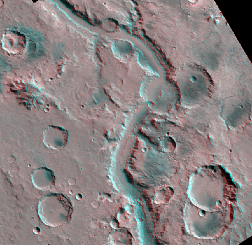 This large
martian outflow channel, Ma'adim Vallis, is about 20 kilometers wide and
2 kilometers deep in this area and at least 700 kilometers long overall. Ma'adim
Vallis formed in the ancient martian highlands and may be as old as 3.5 billion
years. Similar outflow channels drain into the Chryse Basin on Mars. Channels such as
these are among the best evidence for abundant quantities of groundwater or ice in the
early history of Mars. They may have formed by the sudden release of massive amounts of
groundwater or melted ground ice. Channel enlargement has been due to erosion and slumping
of the rim. Some of the short narrow channels along the walls of Ma'adim are probably
sapping channels. [Numerous side canyons at Valles Marineris (slide #24) and the Grand
Canyon (slide #12) may also be sapping channels.] Sapping occurs when groundwater
partially dissolves and undermines the rock, which collapses into debris deposits and is
carried away by other erosional processes. (Viking 1 images 597A56, 631A58.)
This large
martian outflow channel, Ma'adim Vallis, is about 20 kilometers wide and
2 kilometers deep in this area and at least 700 kilometers long overall. Ma'adim
Vallis formed in the ancient martian highlands and may be as old as 3.5 billion
years. Similar outflow channels drain into the Chryse Basin on Mars. Channels such as
these are among the best evidence for abundant quantities of groundwater or ice in the
early history of Mars. They may have formed by the sudden release of massive amounts of
groundwater or melted ground ice. Channel enlargement has been due to erosion and slumping
of the rim. Some of the short narrow channels along the walls of Ma'adim are probably
sapping channels. [Numerous side canyons at Valles Marineris (slide #24) and the Grand
Canyon (slide #12) may also be sapping channels.] Sapping occurs when groundwater
partially dissolves and undermines the rock, which collapses into debris deposits and is
carried away by other erosional processes. (Viking 1 images 597A56, 631A58.)
Location: 19.0 S, 183.0 W Image Width: 200 kilometers
Vertical Exaggeration: 3.6× normal Image Resolution: 270
meters/pixel
26. Valley Networks in Libya Montes Tyrrhena Terra,
Mars
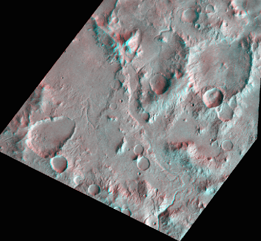 Libya
Montes forms the eroded and cratered remains of the southern rim of the
1100-kilometer-wide Isidis impact basin on Mars. These highlands have been heavily eroded
by valley networks draining northward into the basin. This drainage has carved deep
valleys (for example, at bottom center), eroded large areas, and deposited sediments in
low areas. Valley networks such as these are common throughout the equatorial highlands of
Mars and may be a direct result of extended periods of rainfall or melted snowfall early
in martian history. At least one crater (oval crater at lower left) appears to have been
partially filled by sediment, probably as a result of extensive depositional processes.
This crater may possibly have contained a lake of standing water at one time. These
features point to a more active erosional history on Mars in the past. (Viking 1 images
876A01, 377S79.)
Libya
Montes forms the eroded and cratered remains of the southern rim of the
1100-kilometer-wide Isidis impact basin on Mars. These highlands have been heavily eroded
by valley networks draining northward into the basin. This drainage has carved deep
valleys (for example, at bottom center), eroded large areas, and deposited sediments in
low areas. Valley networks such as these are common throughout the equatorial highlands of
Mars and may be a direct result of extended periods of rainfall or melted snowfall early
in martian history. At least one crater (oval crater at lower left) appears to have been
partially filled by sediment, probably as a result of extensive depositional processes.
This crater may possibly have contained a lake of standing water at one time. These
features point to a more active erosional history on Mars in the past. (Viking 1 images
876A01, 377S79.)
Location: 2.0 N, 275.0 W Image Width: 200 kilometers
Vertical Exaggeration: ~3.2× normal Image Resolution: 260
meters/pixel
27. Rabe (Terrain Softening) Noachis Terra, Mars
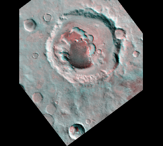 The
110-kilometer-wide impact crater at center, Rabe, is typical of those in the cratered
highlands west of the Hellas impact basin. Most of these craters appear to be very
degraded. Raised rims, terraces, central peaks, and other morphologic features and
structures that characterize relatively fresh craters (slide #16) are virtually absent,
and have been heavily eroded or blanketed. Only one crater, at the bottom of the scene,
looks deep and fresh. The degradation of topography on Mars is termed "terrain
softening." Terrain softening may be due to the slow but steady downslope movement of
regolith and soil, a process called creep. This process may indicate the presence of
ground ice on Mars, which would enhance creep of the soil. Alternatively, the softened
appearance could result from a long history of deposition by airfall. In the martian
highlands, dark spots are common within the floors of craters. Here, a dark spot is
resolved into a field of dunes. The dunes may be the remnants of crater-filling deposits
or accumulations of windblown sand that formed in the topographic trap at the bottom of
the crater. (Viking 1 images 510A29, 094A49.)
The
110-kilometer-wide impact crater at center, Rabe, is typical of those in the cratered
highlands west of the Hellas impact basin. Most of these craters appear to be very
degraded. Raised rims, terraces, central peaks, and other morphologic features and
structures that characterize relatively fresh craters (slide #16) are virtually absent,
and have been heavily eroded or blanketed. Only one crater, at the bottom of the scene,
looks deep and fresh. The degradation of topography on Mars is termed "terrain
softening." Terrain softening may be due to the slow but steady downslope movement of
regolith and soil, a process called creep. This process may indicate the presence of
ground ice on Mars, which would enhance creep of the soil. Alternatively, the softened
appearance could result from a long history of deposition by airfall. In the martian
highlands, dark spots are common within the floors of craters. Here, a dark spot is
resolved into a field of dunes. The dunes may be the remnants of crater-filling deposits
or accumulations of windblown sand that formed in the topographic trap at the bottom of
the crater. (Viking 1 images 510A29, 094A49.)
Location: 44.0 S, 325.0 W Image Width: 150 kilometers
Vertical Exaggeration: 3.3× normal Image Resolution: 200
meters/pixel
28. A Mars felszíne ("Twin Peaks") Ares
Vallis, Mars
![]() Mars
Pathfinder obtained this 3-D view of the surface of Mars shortly after landing on July 4,
1997. Visible in this scene are a variety of rocks. The two hills (dubbed "Twin
Peaks") on the horizon are 1-2 kilometers away and are visible from orbit. The
Mars Pathfinder landing site is at the mouth of Ares Vallis, a large outflow channel
1500 kilometers long that emptied from the martian highlands into the Chryse Basin.
Vast floodwaters, similar to those which carved Ma'adim Vallis (slide #26), poured over
this site several billion years ago. The rounded rocks in the foreground may have been
transported and eroded during these floods. Twin Peaks may also have been eroded by these
floodwaters. (Mars Pathfinder images; image processing by Tim Parker, Jet Propulsion
Laboratory.)
Mars
Pathfinder obtained this 3-D view of the surface of Mars shortly after landing on July 4,
1997. Visible in this scene are a variety of rocks. The two hills (dubbed "Twin
Peaks") on the horizon are 1-2 kilometers away and are visible from orbit. The
Mars Pathfinder landing site is at the mouth of Ares Vallis, a large outflow channel
1500 kilometers long that emptied from the martian highlands into the Chryse Basin.
Vast floodwaters, similar to those which carved Ma'adim Vallis (slide #26), poured over
this site several billion years ago. The rounded rocks in the foreground may have been
transported and eroded during these floods. Twin Peaks may also have been eroded by these
floodwaters. (Mars Pathfinder images; image processing by Tim Parker, Jet Propulsion
Laboratory.)
29. A Mars felszíne (Sojourner) Ares Vallis, Mars
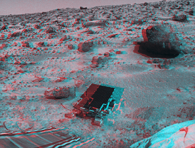 Mars
Pathfinder obtained this 3-D view of the microrover Sojourner shortly after it rolled onto
the martian surface on July 5, 1997. Sojourner is 63 centimeters (25 inches)
long and weighs about 10 kilograms. The ramp used by the rover to move onto the
surface is visible in the foreground. Also visible are a variety of rocks, including
"Barnacle Bill," located next to Sojourner. Barnacle Bill was the first rock
analyzed by the rover. The largest rock in the scene is "Yogi," which is
1-2 meters across. The Mars Pathfinder landing site is at the mouth of Ares Vallis, a
large outflow channel that emptied into the Chryse Basin. Vast floodwaters poured over
this site several billion years ago. (Mars Pathfinder images.)
Mars
Pathfinder obtained this 3-D view of the microrover Sojourner shortly after it rolled onto
the martian surface on July 5, 1997. Sojourner is 63 centimeters (25 inches)
long and weighs about 10 kilograms. The ramp used by the rover to move onto the
surface is visible in the foreground. Also visible are a variety of rocks, including
"Barnacle Bill," located next to Sojourner. Barnacle Bill was the first rock
analyzed by the rover. The largest rock in the scene is "Yogi," which is
1-2 meters across. The Mars Pathfinder landing site is at the mouth of Ares Vallis, a
large outflow channel that emptied into the Chryse Basin. Vast floodwaters poured over
this site several billion years ago. (Mars Pathfinder images.)
30. Grooves and Craters Phobos, Mars
 Linear
grooves such as these are common on the martian moon Phobos. These grooves are
200-300 meters across, up to 30 meters deep, and up to 20 kilometers long.
In some cases, these grooves are actually a series of aligned pits that form a chain. The
grooves may result from fractures within Phobos created during the formation of the
10-kilometer-diameter crater Stickney, located just off the left edge of the image. The
wide grooves may have formed when regolith and soil drained into these fractures. (Viking
1 images 343A15, 343A29.)
Linear
grooves such as these are common on the martian moon Phobos. These grooves are
200-300 meters across, up to 30 meters deep, and up to 20 kilometers long.
In some cases, these grooves are actually a series of aligned pits that form a chain. The
grooves may result from fractures within Phobos created during the formation of the
10-kilometer-diameter crater Stickney, located just off the left edge of the image. The
wide grooves may have formed when regolith and soil drained into these fractures. (Viking
1 images 343A15, 343A29.)
Location: 20.0 N, 0.0 W Image Width: 7 kilometers
Vertical Exaggeration: 3.0× normal Image Resolution: 8
meters/pixel
31. Gaspra Kisbolygó
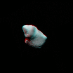 The
asteroid Gaspra is 9 × 18 kilometers across. It has an angular shape and may be
a fragment produced by the impact disruption of a larger parent asteroid. Gaspra is one of
well over 4000 rocky asteroids, most of which orbit between Mars and Jupiter. They range
in size from 900 kilometers (Ceres) to "rocks" less than 1 kilometer
across, and are either the shattered remains of a planet or pieces of a planets that never
formed. Galileo obtained these views of Gaspra in 1991 from a distance of about
20,000 kilometers and a resolution of roughly 200 meters.
The
asteroid Gaspra is 9 × 18 kilometers across. It has an angular shape and may be
a fragment produced by the impact disruption of a larger parent asteroid. Gaspra is one of
well over 4000 rocky asteroids, most of which orbit between Mars and Jupiter. They range
in size from 900 kilometers (Ceres) to "rocks" less than 1 kilometer
across, and are either the shattered remains of a planet or pieces of a planets that never
formed. Galileo obtained these views of Gaspra in 1991 from a distance of about
20,000 kilometers and a resolution of roughly 200 meters.
32. Haemus Montes Io, Jupiter
 This 3-D
Voyager 1 view features Haemus Montes, a prominent mountain near the south pole of
Jupiter's large satellite Io. Haemus Montes is about 150 kilometers across and
consists of two sections. A broad plateau 4 kilometers high forms the eastern portion
(to the left; north is down in this view). The western portion rises about
9 kilometers above the surrounding plains. The numerous parallel striations across
Haemus Montes suggest that the mountain is intensely fractured or consists of layered
volcanic deposits. The origin of the mountain is uncertain, but may be due to uplift of
large blocks of crust along thrust faults. Mountains cover only a few percent of Io's
surface but indicate that Io's crust is probably composed mostly of silicates rather than
sulfur compounds. Sulfur is too weak a geologic material and would not support mountains
9 kilometers high. The bright ring or aureole surrounding Haemus Montes is probably
composed of sulfur dioxide frost, which may have been vented from aquifers of sulfur
dioxide within Haemus Montes. The "natural" color of Io is a greenish yellow
because of the presence of sulfur. The colors shown here are real but are enhanced. (Voyager
1 images 16392.00, 16393.01.)
This 3-D
Voyager 1 view features Haemus Montes, a prominent mountain near the south pole of
Jupiter's large satellite Io. Haemus Montes is about 150 kilometers across and
consists of two sections. A broad plateau 4 kilometers high forms the eastern portion
(to the left; north is down in this view). The western portion rises about
9 kilometers above the surrounding plains. The numerous parallel striations across
Haemus Montes suggest that the mountain is intensely fractured or consists of layered
volcanic deposits. The origin of the mountain is uncertain, but may be due to uplift of
large blocks of crust along thrust faults. Mountains cover only a few percent of Io's
surface but indicate that Io's crust is probably composed mostly of silicates rather than
sulfur compounds. Sulfur is too weak a geologic material and would not support mountains
9 kilometers high. The bright ring or aureole surrounding Haemus Montes is probably
composed of sulfur dioxide frost, which may have been vented from aquifers of sulfur
dioxide within Haemus Montes. The "natural" color of Io is a greenish yellow
because of the presence of sulfur. The colors shown here are real but are enhanced. (Voyager
1 images 16392.00, 16393.01.)
Location: 70.0 S, 45.0 W Image Width: 270 kilometers
Vertical Exaggeration: 5.2× normal Image Resolution:430
meters/pixel
33. Isis (Central Pit Crater) Ganymedes, Jupiter
 Ganymede is
roughly evenly divided between dark terrain (the triangular-shaped regions) and broad
swaths of bright terrain. Dark terrain is older and more heavily cratered than bright
terrain. Bright terrain probably formed when extensional graben that crossed dark terrain
were partially filled with bright material, possibly erupted flows of liquid water. The
central pit crater Isis is 75 kilometers wide and roughly 2 kilometers deep.
Central pits, which have low-relief rims, are common in large craters on the large icy
satellites Ganymede and Callisto but also occur on Mars [compare this crater to complex
craters on other planets (slides #3, #16, and #36)]. The origin of central pits is not
fully understood, but may be related to the ice-rich composition of Ganymede's crust.
Topographic relief on Ganymede, including the largest impact basins, rarely exceeds
2 kilometers. In contrast, the largest impact basins on the Moon are
12 kilometers deep. The low relief on Ganymede is probably related to the ice-rich
composition of Ganymede's outer layers. Ice is much weaker than ordinary rock and cannot
support high topography on Ganymede, which has a higher surface gravity than any other icy
satellite. (Voyager 2 images 20636.38, 20640.33.)
Ganymede is
roughly evenly divided between dark terrain (the triangular-shaped regions) and broad
swaths of bright terrain. Dark terrain is older and more heavily cratered than bright
terrain. Bright terrain probably formed when extensional graben that crossed dark terrain
were partially filled with bright material, possibly erupted flows of liquid water. The
central pit crater Isis is 75 kilometers wide and roughly 2 kilometers deep.
Central pits, which have low-relief rims, are common in large craters on the large icy
satellites Ganymede and Callisto but also occur on Mars [compare this crater to complex
craters on other planets (slides #3, #16, and #36)]. The origin of central pits is not
fully understood, but may be related to the ice-rich composition of Ganymede's crust.
Topographic relief on Ganymede, including the largest impact basins, rarely exceeds
2 kilometers. In contrast, the largest impact basins on the Moon are
12 kilometers deep. The low relief on Ganymede is probably related to the ice-rich
composition of Ganymede's outer layers. Ice is much weaker than ordinary rock and cannot
support high topography on Ganymede, which has a higher surface gravity than any other icy
satellite. (Voyager 2 images 20636.38, 20640.33.)
Location: 68.0 S, 192.0 W Image Width: 320 kilometers
Vertical Exaggeration: 6.3× normal Image Resolution: 470
meters/pixel
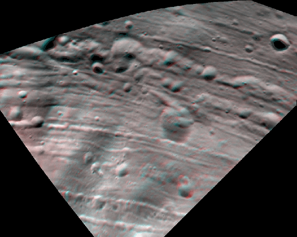
34. Galileo Regio Ganymedes, Jupiter
 This rugged
terrain is part of Galileo Regio, a large area of dark terrain on Jupiter's large icy
satellite Ganymede. Dark terrain is the oldest preserved terrain on Ganymede and is
heavily cratered. Several intersecting furrows are also visible in this view (lower center
and upper right). Furrows are parallel and intersecting linear troughs
10-30 kilometers across with raised rims. They are probably extensional fault valleys
and may be the remnants of a very large ancient impact basin. The rounded topography of
the troughs, craters, and hills in this region indicate that this terrain has been eroded.
This erosion may involve the downslope creep of rock-rich material into the lowlands,
exposing ice-rich material on the hills. (Galileo images 349759026, 359944739.)
This rugged
terrain is part of Galileo Regio, a large area of dark terrain on Jupiter's large icy
satellite Ganymede. Dark terrain is the oldest preserved terrain on Ganymede and is
heavily cratered. Several intersecting furrows are also visible in this view (lower center
and upper right). Furrows are parallel and intersecting linear troughs
10-30 kilometers across with raised rims. They are probably extensional fault valleys
and may be the remnants of a very large ancient impact basin. The rounded topography of
the troughs, craters, and hills in this region indicate that this terrain has been eroded.
This erosion may involve the downslope creep of rock-rich material into the lowlands,
exposing ice-rich material on the hills. (Galileo images 349759026, 359944739.)
Location: 20.0 N, 148.0 W Image Width:60 kilometers
Vertical Exaggeration: 1.5× normal Image Resolution: 70
meters/pixel
35. Saturn
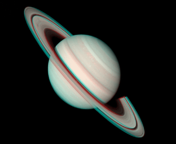 Saturn is
120,000 kilometers across and is the second largest planet in the solar system. This
3-D view was constructed from two Voyager 2 images taken several weeks apart in 1981.
It allows us to view the planet and rings as three-dimensional objects, but was obtained
too far from Saturn to reveal details of its outer cloud deck and ring system. The low
density of Saturn indicates that it is primarily composed of gaseous and liquid hydrogen
and helium, and is similar in composition to our Sun. The density of Saturn is low enough
that it would float in water. Most of the clouds we see are probably composed of
ammonia-ice crystals. Saturn's famous ring system is actually comprised of billions of icy
particles ranging in size from dust particles to house-sized boulders. The main rings form
a flat gravitationally controlled annular disk only a few kilometers thick and
extending roughly 140,000 kilometers from the cloud tops. (Voyager 2 images.)
Saturn is
120,000 kilometers across and is the second largest planet in the solar system. This
3-D view was constructed from two Voyager 2 images taken several weeks apart in 1981.
It allows us to view the planet and rings as three-dimensional objects, but was obtained
too far from Saturn to reveal details of its outer cloud deck and ring system. The low
density of Saturn indicates that it is primarily composed of gaseous and liquid hydrogen
and helium, and is similar in composition to our Sun. The density of Saturn is low enough
that it would float in water. Most of the clouds we see are probably composed of
ammonia-ice crystals. Saturn's famous ring system is actually comprised of billions of icy
particles ranging in size from dust particles to house-sized boulders. The main rings form
a flat gravitationally controlled annular disk only a few kilometers thick and
extending roughly 140,000 kilometers from the cloud tops. (Voyager 2 images.)
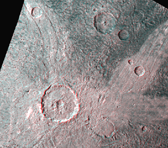
36. Ormazd Region Rhea, Szaturnusz
 The
middle-sized icy saturnian satellite Rhea may be one of the most heavily cratered objects
in the solar system. The largest crater in this scene, Ormazd (upper right), is
130 kilometers across and roughly 5 kilometers deep. Compare the surface of Rhea
with that of Uranus' satellite Miranda (slide #37), which is less than half the size of
Rhea. No smooth or resurfaced areas are apparent on Rhea, even in this stereo view. If
there has ever been significant volcanic activity on Rhea similar to that on Enceladus,
Dione, or Miranda, it must have occurred very early in Rhea's history and has been
destroyed by the formation of later impact craters. (Voyager 1 images 34950.47,
34952.57.)
The
middle-sized icy saturnian satellite Rhea may be one of the most heavily cratered objects
in the solar system. The largest crater in this scene, Ormazd (upper right), is
130 kilometers across and roughly 5 kilometers deep. Compare the surface of Rhea
with that of Uranus' satellite Miranda (slide #37), which is less than half the size of
Rhea. No smooth or resurfaced areas are apparent on Rhea, even in this stereo view. If
there has ever been significant volcanic activity on Rhea similar to that on Enceladus,
Dione, or Miranda, it must have occurred very early in Rhea's history and has been
destroyed by the formation of later impact craters. (Voyager 1 images 34950.47,
34952.57.)
Location: 45.5 N, 18.0 W Image Width: 640 kilometers
Vertical Exaggeration: 6.1× normal Image Resolution: 800
meters/pixel
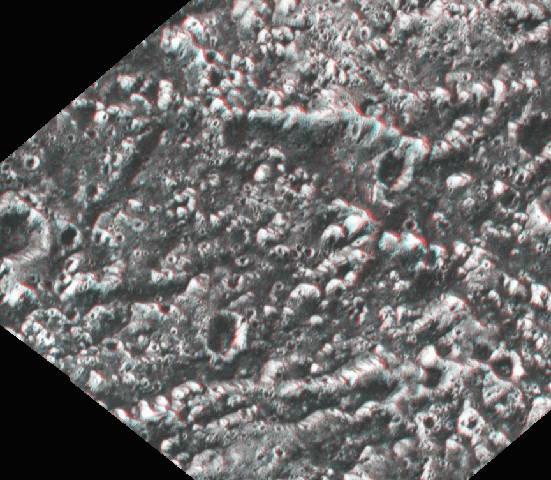
37. Coronae Miranda, Uránusz
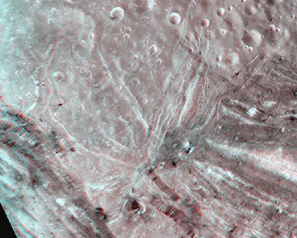 Despite its
small size (only 470 kilometers across), Uranus' small icy satellite Miranda has had
a surprisingly diverse and complex geologic history, concentrated in three dark oval- to
square-shaped regions called coronae. This image shows portions of two coronae, Arden
Corona at lower left and Inverness Corona at right. Coronae are 100-300 kilometers
across and consist of a central zone of chaotic ridges surrounded by a zone of concentric
ridges and fractures. Ridges appear to be extensional fault blocks in some areas and
volcanic extrusions in other areas. The extruded ridges are up to 2 kilometers high
and may be composed of ammonia-water lavas.
Despite its
small size (only 470 kilometers across), Uranus' small icy satellite Miranda has had
a surprisingly diverse and complex geologic history, concentrated in three dark oval- to
square-shaped regions called coronae. This image shows portions of two coronae, Arden
Corona at lower left and Inverness Corona at right. Coronae are 100-300 kilometers
across and consist of a central zone of chaotic ridges surrounded by a zone of concentric
ridges and fractures. Ridges appear to be extensional fault blocks in some areas and
volcanic extrusions in other areas. The extruded ridges are up to 2 kilometers high
and may be composed of ammonia-water lavas.
The concentric pattern of volcanism and tectonism within coronae suggests that they
formed over plumes of material rising from the core of Miranda. These plumes spread out as
they neared the surface, fracturing the crust and triggering local volcanism. The geologic
complexity of Miranda is puzzling because it should have been cold and inactive since
shortly after its formation. The heat required to melt large parts of the interior may
have been provided by tidal interactions with neighboring satellites and Uranus itself.
Similar tidal heating powers the volcanism on Jupiter's moon Io. (Voyager 2 images
26846.11, 26846.14, 26846.26.)
Location: 75.0 S, 40.0 E Image Width: ~230 kilometers
Vertical Exaggeration: 1.6× normal Image Resolution: 310
meters/pixel
38. Sylph Chasma Region Ariel, Uránusz
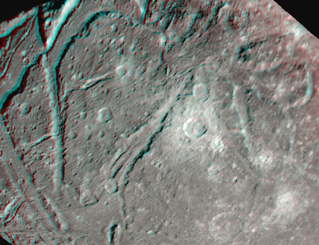 The surface
and geologic history of Uranus' icy satellite Ariel is surprisingly complex compared to
other icy satellites of similar size. Volcanism, faulting, and impact craters seen in this
view of the southern hemisphere have essentially reshaped Ariel's surface since its
formation. The most prominent topographic features are wide steep-walled canyons or
chasmata 3-5 kilometers deep (center and upper left). The youngest of these, Sylph
Chasma, crosses the center of view and has a raised rim that stands above the surrounding
topography. Tilted crustal blocks are visible at upper left and upper right. Several
patches of smooth plains (at bottom) up to 200 kilometers across occur on Ariel.
These plains appear to be lava flows and may be composed of ammonia-water mixtures. The
floors of the canyons also appear to be partially filled with viscous lava plains of
similar composition. Tidal heating may have been responsible for the tectonic and volcanic
activity observed on Ariel, which measures only 1160 kilometers across. (Voyager 2
images 26843.38, 26845.33.)
The surface
and geologic history of Uranus' icy satellite Ariel is surprisingly complex compared to
other icy satellites of similar size. Volcanism, faulting, and impact craters seen in this
view of the southern hemisphere have essentially reshaped Ariel's surface since its
formation. The most prominent topographic features are wide steep-walled canyons or
chasmata 3-5 kilometers deep (center and upper left). The youngest of these, Sylph
Chasma, crosses the center of view and has a raised rim that stands above the surrounding
topography. Tilted crustal blocks are visible at upper left and upper right. Several
patches of smooth plains (at bottom) up to 200 kilometers across occur on Ariel.
These plains appear to be lava flows and may be composed of ammonia-water mixtures. The
floors of the canyons also appear to be partially filled with viscous lava plains of
similar composition. Tidal heating may have been responsible for the tectonic and volcanic
activity observed on Ariel, which measures only 1160 kilometers across. (Voyager 2
images 26843.38, 26845.33.)
Location: 50.0 S, 0.0 E Image Width: 640 kilometers
Vertical Exaggeration: 3.4× normal Image Resolution: 1
kilometer/pixel
39. A Plútó és a Charon
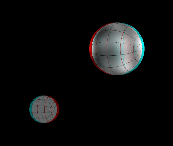 Pluto and
its large satellite, Charon, have not been visited by spacecraft (although they may be the
target of a proposed mission in the early twenty-first century). This 3-D view of Pluto
and Charon was created at the Lunar and Planetary Institute using a map of Pluto's surface
created by Marc Buie and Alan Stern from Hubble Space Telescope (HST) images. Pluto is
2300 kilometers across, and Charon is 1200 kilometers across. The smallest
features detectable on the Pluto map are roughly 200 kilometers across. In this view,
the Pluto-Charon system is shown from the side, with the north pole of each object
pointing toward the right. This view is similar to that of HST in 1994, when the image map
was obtained. Charon, represented by a gray sphere, is in front of Pluto and orbits from
top to bottom across the scene. Latitude and longitude lines have been added to aid in
viewing the stereo effect.
Pluto and
its large satellite, Charon, have not been visited by spacecraft (although they may be the
target of a proposed mission in the early twenty-first century). This 3-D view of Pluto
and Charon was created at the Lunar and Planetary Institute using a map of Pluto's surface
created by Marc Buie and Alan Stern from Hubble Space Telescope (HST) images. Pluto is
2300 kilometers across, and Charon is 1200 kilometers across. The smallest
features detectable on the Pluto map are roughly 200 kilometers across. In this view,
the Pluto-Charon system is shown from the side, with the north pole of each object
pointing toward the right. This view is similar to that of HST in 1994, when the image map
was obtained. Charon, represented by a gray sphere, is in front of Pluto and orbits from
top to bottom across the scene. Latitude and longitude lines have been added to aid in
viewing the stereo effect.
Pluto and Charon are probably composed of roughly 50% rock and 50% ice. The bright and dark spots may be deposits of nitrogen, methane, carbon monoxide, or carbon dioxide frosts and ices. Water ice has also been detected. The frost patterns may be seasonal deposits formed by Pluto's thin atmosphere. Whether impact craters or volcanos exist on the surface is not known.
40. Átekintés Naprendszer
 With the
exception of outermost Pluto, the nine planets orbit the Sun in nearly the same plane, as
shown in this oblique view of the solar system. The solar system is also populated by
numerous small bodies, including asteroids and comets, that circle the Sun like a swarm of
bees. The highly elliptical orbits of three representative comets, Hale-Bopp (toward
bottom), Halley (toward lower right), and Grigg-Skjellurup (toward left) are shown.
Hale-Bopp is a long-period comet with a period of 4000 years or so. Halley is a
short-period comet with an orbital period of 76 years and an orbit that extends out
to Neptune. Grigg-Skjellurup is a short-period comet (period of 5 years) whose orbit
is influenced by the planet Jupiter. Comets are composed of rock and ices and probably
originated from beyond Neptune before being deflected into the inner solar system. Pluto
probably represents the largest member of a newly discovered but previously predicted
class of small bodies, called Kuiper Belt objects, that orbit beyond Neptune. In this
view, all the orbits are shown to scale but the images of the planets are greatly
enlarged.
With the
exception of outermost Pluto, the nine planets orbit the Sun in nearly the same plane, as
shown in this oblique view of the solar system. The solar system is also populated by
numerous small bodies, including asteroids and comets, that circle the Sun like a swarm of
bees. The highly elliptical orbits of three representative comets, Hale-Bopp (toward
bottom), Halley (toward lower right), and Grigg-Skjellurup (toward left) are shown.
Hale-Bopp is a long-period comet with a period of 4000 years or so. Halley is a
short-period comet with an orbital period of 76 years and an orbit that extends out
to Neptune. Grigg-Skjellurup is a short-period comet (period of 5 years) whose orbit
is influenced by the planet Jupiter. Comets are composed of rock and ices and probably
originated from beyond Neptune before being deflected into the inner solar system. Pluto
probably represents the largest member of a newly discovered but previously predicted
class of small bodies, called Kuiper Belt objects, that orbit beyond Neptune. In this
view, all the orbits are shown to scale but the images of the planets are greatly
enlarged.
GEOLOGIC TOUR
The Solar System in 3-D can also be used to illustrate the diversity of geologic features
on the planets. Below we provide a sample tour that will show volcanos, tectonic features,
impact craters, and atmospheric features. Note that several slides appear more than once
because they show more than one geologic feature.
Volcanism
Volcanos and lava flows are an indication that a planet is hot inside, hot enough to
partially melt some of the rock. Some of this melted rock can erupt on the surface. More
viscous lavas tend to form thicker lava flows. On the icy satellites, these lavas consist
of melted ices, including water and ammonia-water mixtures.
Plains Volcanism and Calderas
15. Montes Haemus / Mare Serenitatis, Moon
5. Calderas and Tessera / Ovda Regio, Venus
11. Owens Valley / California and Nevada, USA, Earth
33. Isis (Central Pit Crater) / Ganymede, Jupiter
Domes and Ridges
4. Carmenta Farra (Pancake Domes) / Eistla Regio, Venus
37. Coronae / Miranda, Uranus
38. Sylph Chasma Region / Ariel, Uranus
Shield Volcanos and Stratovolcanos
8. Mount St. Helens / Washington, USA, Earth
9. Eruption of Klyuchevskaya / Kamchatka, Russia, Earth
10. Kurile-Kamchatka Trench / Northwestern Pacific Basin, Earth
23. Apollinaris Patera / Elysium Planitia, Mars
Tectonism
Extensional fractures and graben form when the crust is stretched. Compressional folds and
ridges form when the crust is compressed. Both styles can occur when a planet changes
shape as it cools, or when internal activity causes deformation of the crust.
Extensional Tectonics
30. Grooves and Craters / Phobos, Mars
15. Montes Haemus / Mare Serenitatis, Moon
34. Galileo Regio / Ganymede, Jupiter
38. Sylph Chasma Region / Ariel, Uranus
11. Owens Valley / California and Nevada, USA, Earth
24. Tithonium Chasma / Valles Marineris, Mars
6. Corona / Ovda Regio, Venus
37. Coronae / Miranda, Uranus
5. Calderas and Tessera / Ovda Regio, Venus
Compressional Tectonics
7. Ridge Belt / Ishtar Terra, Venus
2. Discovery Rupes / Discovery Region, Mercury
15. Montes Haemus / Mare Serenitatis, Moon
10. Kurile-Kamchatka Trench / Northwestern Pacific Basin, Earth
32. Haemus Montes / Io, Jupiter
Impact Cratering
The surfaces of the planets have been subjected to a continual rain of impacts from
meteorites, asteroids, and comets. These strike with tremendous force and can create
craters from millimeters to thousands of kilometers across. Some can shatter a small moon
or planet. These views of impact craters are arranged in order of increasing size, and
illustrate how morphology is more complex in larger craters.
From Microcraters to Impact Basins
22. Surface of the Moon — Soil Close-Up / Fra Mauro Highlands, Moon
30. Grooves and Craters / Phobos, Mars
15. Montes Haemus / Mare Serenitatis, Moon
4. Carmenta Farra (Pancake Domes) / Eistla Regio, Venus
3. Kaikilani (Complex Crater) / Nsomeka Planitia, Venus
36. Ormazd Region / Rhea, Saturn
16. King (Complex Crater) / Farside Terra, Moon
33. Isis (Central Pit Crater) / Ganymede, Jupiter
17. Catena Davy (Imbrium Basin Ejecta) / Mare Nubium, Moon
Impact Craters and the Landscape
19. Surface of the Moon — Boulders / Taurus-Littrow Valley, Moon
34. Galileo Regio / Ganymede, Jupiter
31. Gaspra / Asteroid Belt
Atmospheres, Rivers, and Erosion
Several planets, a few satellites, and the Sun have atmospheres. These can be thin gaseous
envelopes or cloudy and stormy. An atmosphere can also produce precipitation of liquid
water on the surface, which is a very effective agent of erosion. Erosion can also occur
by creep of soils or by landslides.
Atmospheres and Storms
1. The Solar Corona in X-Rays / Sun
35. Saturn
13. Thunderstorms / Brazil, Earth
14. Eye, Typhoon Emilia / Western Pacific, Earth
River and Glacier Valleys
12. Grand Canyon / Arizona, USA, Earth
11. Owens Valley / California and Nevada, USA, Earth
25. Ma'adim Vallis / Terra Cimmeria, Mars
26. Valley Networks in Libya Montes / Tyrrhena Terra, Mars
Erosion
24. Eastern Tithonium Chasma / Valles Marineris, Mars
27. Rabe (Terrain Softening) / Noachis Terra, Mars
28. Surface of Mars ("Twin Peaks") / Ares Vallis, Mars
34. Galileo Regio / Ganymede, Jupiter
Exploration
Only three other planetary bodies have been directly explored by man or by robot: the
Moon, Venus, and Mars. Only one, the Moon, has been visited by astronauts (Apollo,
1969-1972). Stereo images were obtained on the Moon and Mars (but not on Venus). These
views give us a feel for what it might be like to stand on these alien surfaces.
The Moon
18. Apollo 17 Landing Site / Taurus-Littrow Valley, Moon
19. Surface of the Moon — Boulders / Taurus-Littrow Valley, Moon
20. Surface of the Moon — Astronaut / Oceanus Procellarum, Moon
21. Surface of the Moon — Rover / Hadley Rille, Moon
22. Surface of the Moon — Soil Close-Up / Fra Mauro Highlands, Moon
Mars
28. Surface of Mars ("Twin Peaks") / Ares Vallis, Mars
29. Surface of Mars ("Sojourner") / Ares Vallis, Mars
The Solar System
39. Pluto and Charon
40. Overview / Solar System
GLOSSARY
airfall — shower-like falling of pyroclastic fragments from an eruption cloud.
annular disk — a thin, flat, circular object that is shaped like or forms a ring.
basalt — a dark-colored, fine-grained volcanic rock composed of plagioclase (over 50%) and pyroxene. Olivine may or may not be present.
batholith — large body of intrusive igneous rock exposed over an area of at least 100 square kilometers.
caldera — a large, more or less circular depression or basin associated with a volcanic vent. Calderas are believed to result from subsidence or collapse and may or may not be related to explosive eruptions.
corona (pl. coronae) — oval-shaped feature on the surface of Venus or Miranda. Also used to describe the bright, irregular-shaped envelope of ionized gas around the Sun.
dacite — a fine-grained extrusive rock composed mostly of plagioclase feldspar, with amphibole and biotite.
ejecta — the deposit surrounding an impact crater composed of material thrown from the crater during its formation.
graben — an elongate crustal depression bounded by normal faults on its long sides.
groundwater sapping — erosion on the surface of a planet resulting from the seepage of groundwater (subsurface water) onto the surface.
impact melt — molten material produced by fusion of target rock during a meteorite impact, usually found in and around the resulting crater.
mantle — the interior zone of a planet or satellite below the crust and above the core that behaves plastically.
metamorphic rocks — rocks formed from preexisting rocks within a planet's crust by changes in temperature and pressure and by chemical action of fluids.
outflow channel — a valley on Mars consisting of irregular networks, thought to have been formed by the sudden release of water.
rhyolite — a fine-grained volcanic rock composed of quartz, potassium feldspar, and plagioclase. Rhyolite is the extrusive equivalent of a granite.
scarps — steep slopes produced by erosion or faulting.
stratovolcano — a steep-sided volcano built up of alternating layers of ash and lava flows.
subduction — subsidence of the leading edge of a lithospheric plate into the mantle.
tectonism — the process of deformation of planetary materials, for example, faulting of the crust.
SUGGESTED READINGS
General Reading
Baker V. (1982) The Channels of Mars. University of Texas Press, Austin.
198 pp.
Beatty J. K., O'Leary B., and Chaikin A., eds. (1990) The New Solar System. Sky Publishing Corporation, Cambridge, Massachusetts; Cambridge University Press, New York. 326 pp.
Binzel R. P. (1990) Pluto. Scientific American, 262, 50-58.
Carr M. (1981) The Surface of Mars. Yale University Press, New Haven, Connecticut. 232 pp.
Cattermole P. J. (1994) Venus, the Geological Story. Johns Hopkins University Press, Baltimore. 250 pp.
Chaikin A. (1994) A Man on the Moon: The Voyages of the Apollo Astronauts. Viking, New York. 670 pp.
Comets, Asteroids and Meteorites (1990) Voyage Through the Universe series. Time-Life Books, Alexandria, Virginia. 144 pp.
The Far Planets (1988) Voyage Through the Universe series. Time-Life Books, Alexandria, Virginia. 144 pp.
Greeley R. (1993) Planetary Landscapes. Chapman and Hall.
Grinspoon D. H. (1997) Venus Revealed: A New Look Below the Clouds of Our Mysterious Twin Planet. Addison-Wesley, Reading, Massachusetts. 355 pp.
Miller R. et al. (1983) Continents in Collision. Planet Earth series. Time-Life Books, Alexandria, Virginia. 176 pp.
Rothery D. (1992) Satellites of the Outer Planets. Clarendon Press, Oxford. 208 pp.
Short N. and Blair R. (1986) Geomorphology from Space. NASA Special Publication 486.
Strom R. G. (1987) Mercury: The Elusive Planet. Smithsonian Institution Press, Washington, DC. 197 pp.
The Sun (1990) Voyage Through the Universe series. Time-Life Books, Alexandria, Virginia. 144 pp.
Whipple A. B. C. et al. (1982) Storm. Planet Earth series. Time-Life Books, Alexandria, Virginia. 176 pp.
Wilhelms D. (1993) To a Rocky Moon. University of Arizona Press, Tucson. 477 pp.
Williams J. (1992) The Weather Book. Vintage Books, New York. 212 pp.
Technical Reading
Burns J., and Matthews M., eds. (1986) Satellites. University of Arizona Press,
Tucson. 1021 pp.
Carr M. (1996) Water on Mars. Oxford University Press, New York. 229 pp.
Condie K. (1989) Plate Tectonics and Crustal Evolution. Pergamon, New York. 288 pp.
Elston D. P., Billingsley G. H., and Young R. A., eds. (1989) Geology of Grand Canyon, Northern Arizona. American Geophysical Union, Washington, DC. 239 pp.
Lipman P. and Mullineaux D. (1981) The 1980 Eruptions of Mount St. Helens, Washington. U.S. Geological Survey Professional Paper 1250. 844 pp.
Melosh H. (1989) Impact Cratering. Oxford University Press, New York. 245 pp.
Morrison D., ed. (1982) Satellites of Jupiter. University of Arizona Press, Tucson. 972 pp.
Pappalardo R. T. et al. (1997) Extensional tilt blocks on Miranda: Evidence for an upwelling origin of Arden Corona. Journal of Geophysical Research, 102, 13369.
Schenk P. (1991) Fluid volcanism on Miranda and Ariel. Journal of Geophysical Research, 96, 1887-1906.
Schultz P. (1976) Moon Morphology. University of Texas Press, Austin. 626 pp.
Stern S. A. (1992) The Pluto-Charon system. Annual Reviews of Astronomy and Astrophysics, 30, 185.
Stern S. A., Buie M., and Trafton L. (1997) HST images and maps of Pluto. Astronomical Journal, 113, 827.
Vilas F. et al., eds. (1986) Mercury. University of Arizona Press, Tucson. 794 pp.
Wilhelms D. (1987) The Geologic History of the Moon. U.S. Geological Survey Professional Paper 1348. 302 pp.
ABOUT THE AUTHORS
The senior author, Dr. Paul Schenk, is a staff scientist at the Lunar and Planetary
Institute. Dr. Schenk completed his Ph.D. in planetary geosciences in 1988 at Washington
University in St. Louis, Missouri. Since joining the research staff at the LPI in 1991, he
has been using Voyager and Viking stereo images to map the topography and geology of the
icy outer planet satellites and Mars. Dr. Schenk has been a stereo image afficionado for
many years, and became interested in stereo images of the planets because they reveal
geologic features not otherwise visible, thereby greatly aiding our understanding of how
and why features on the planets formed.
David Gwynn is currently a graduate student at Texas A&M University, studying the topography and formation of alluvial fan deposits on Earth and Mars. James Tutor has been an undergraduate research assistant at LPI and NASA Johnson Spacecraft Center for the past several years.
The Lunar and Planetary Institute is operated by the Universities Space Research Association under contract number NASW-4574 with the National Aeronautics and Space Administration.
This slide set is LPI Contribution No. 942
 Top of page
 Back to LPI
Slide Sets
Back to LPI
Slide Sets